Search This Blog


Showing posts with label Places. Show all posts

Thursday, July 14, 2011

10 Places You Don’t Want To Live

10 Places You Don’t Want To Live

The world is a giant jigsaw puzzle, spotted with both exquisitely beautiful and potentially dangerous places. While you may dream of spending a lifetime in some of the true paradises-on-earth, you should be equally wary of stepping up in some real hell spots for your own safety. But not everyone is fortunate enough to get a cozy and safe home and there are places on earth where people are actually living on the edge of peril.
Here are top 10 such nightmarish places on earth where you would never want to live:

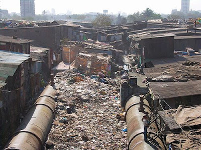
Dharavi in Mumbai, India
The slums of Mumbai
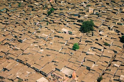
Roughly half the residents of Bombay live in crowded slums such as these.
Photo from bwillen
Sprawling over 175 hectares between Mahim and Sion, Dharavi has emerged as the largest slum of Asia inhabiting a population exceeding 600,000. Dharavi has its rival in Orangi Town in Karachi, Pakistan that has a notorious filth and expanse. Dharavi presents a brighter picture as a cheap pocket in the midst of expensive Mumbai where you could stay for as low as 4 US dollars rent per month.
Dharavi, the most biggest slum of the world / Photo from sandrinecohen22
Dharavi is an abode for various small-scale industries like pottery, embroidered garments, leather and plastic goods. Unbelievably the total net income of the residents of Dharavi amounts to almost 650 million US dollars. But Dharavi is no paradise - its inadequate water supply and toilet facilities get worse during the monsoon floods and the unhygienic environment of Dharavi poses serious threats to public health issues.

Rocinha - Rio de Janeiro, Brazil
Rio de Janeiro, Brazil / Photo from Leonardo Martins
Photo from razorbern
The largest favela (basically meaning shanty town) in Rio De Janeiro. / Photo from -bos[s]-’Situated between the São Conrado and Gávea districts of Rio de Janeiro, Rocinha meaning small ranch in Portuguese is the largest slum or “favela” in South America. Posed on a hillside within one kilometer of the beach, Rocinha originated as a shanty to transform quickly into a modern slum neighborhood. You will find it better off than many shanties because of its brick buildings, sanitation, plumbing and other urban facilities.
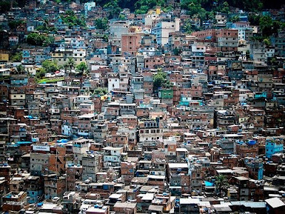
Favela, Rio de Janeiro / Photo from dreamindly
What makes Rocinha a potentially dangerous place to live is the prevalence of a violent drug trade. This leads to endless tussles and encounters between the drug peddlers and the police, giving rise to a dangerous ambiance. The population of 100,000 has a poor economic state and high mortality rates. What is more, Rocinha being built on steep mountain slope is susceptible to landslides, rock falls and floods.

Kibera in Nairobi, Kenya
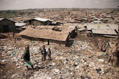
1,000,000 residents live on a mountain of Garbage. / Photo from Chicago Wedding Photographer, Wes Craft
Kibera, meaning ‘forest’ in Nubian is the home for a million people, which earned notoriety for being the biggest slum in the whole of Africa. Most of the population here are tenants with no rights living in mud-walled shacks owned by landlords who have vacated Kibera. Most of the population is African Muslims, who huddle up eight per shack, often sleeping on the floors.
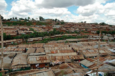
Photo from alongtheway
Just 20% of Kibera has electricity and no regular supply of clean water. The dam water that people use is the root to cholera and typhoid, aggravated by poor sewage condition. There is widespread menace of AIDS and the total absence of government medical facilities. What worsens the general livelihood of Kibera is the availability of a cheap alcoholic drink called ‘Changaa’.
Faced with rampant unemployment, most of the slum-dwellers resort to Changaa early in life and grow into criminals, drunkards and rapists. The problem is aggravated by the availability of cheap drugs and tendencies of glue sniffing. The result is the rising rate of unwanted pregnancy among girls of all ages who invariably turn to abortion. Some charities and churches are working towards the betterment of the condition.
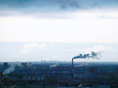
Linfen, China
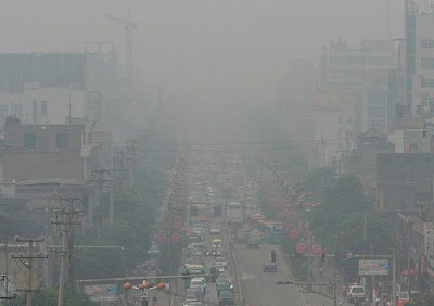
Pollution / Photo from sheilaz413
Located right at the center of Shanxi Province of China’s coal region, Linfen is one of the most polluted cities in the world. The air is thick with dust and smoke to a degree that hampers visibility. The three million people who live in Linfen take regular doses of arsenic rich water, further polluted with fossil fuels and poisonous gases through the air they breathe. You can actually catch a lasting stink when you step in Linfen with overflowing sewage everywhere.
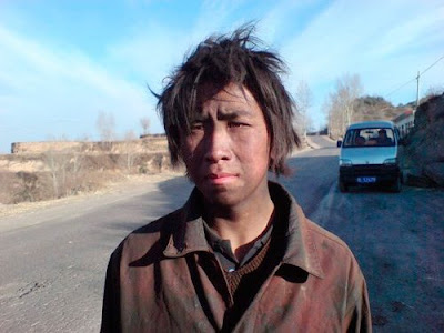
Young coal worker in Linfen (Shanxi, China) / Photo from andi808
The river flowing by Linfen has its water thickened with oil. No wonder! The inhabitants using this water have high occurrences of cancer. When you look at the trees around the Linfen factories, they present a sad withered picture. It is the last place on earth that you would think of sending someone, even your worst enemy.

Kabwe, Zambia
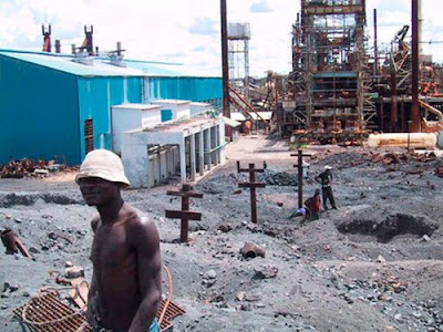
Photograph by Blacksmith Institute / Photo from nationalgeographic.com
The lead and cadmium accumulations in this former British colony have skyrocketed since their discovery in 1902 when Zambia was valued for a rich lead mine. Although the mines have closed and no smelters are operational now, Kabwe residents have faced the threat of lead poisoning through decades. Blood tests in the children have revealed lead concentrations exceeding 5-10 times the normal limit that could turn fatal any day. Only recently, the World Bank has allotted funds for tackling the problem.
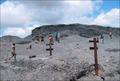
Photo from livescience.com

Chernobyl, Ukraine
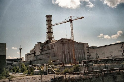
Chernobyl Nuclear Power Plant / Photo from Ken and Nyetta
adiated Apartment Building / Photo from Stuck in Customs
Talking of life-threatening pollution and poisoning, nothing could beat the nuclear reactor accident record set by Chernobyl that has left about 5.5 million people facing the threat of thyroid cancer. The fallout that occurred in April 26, 1986 has led to the leakage of nuclear radiation 100 times more pronounced in volume and effect than that of the Hiroshima and Nagasaki explosions. It is a horror that thousands of Russian, Ukrainian and Belarusian children living close to the damaged plant still cannot escape the radiation impact.
This used to be the public gym, back in 1986. / Photo from philippe simpson
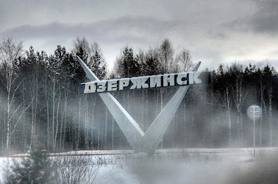
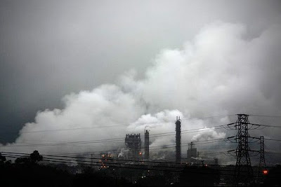
Dzerzhinsk, Russia
Dzerzhinsk / Photo from Oleg aka Xraboy
Situated beside the Oka River in Nizhny Novgorod Oblast of Russia, Dzerzhinsk is named after the Russian leader Feliks Edmundovich Dzerzhinsky. Right From its inception, Dzerzhinsk has remained a chemical industry hub and has been producing chemical weapons for Russia. It has been labeled one of the worst polluted cities of the world with a staggering death rate.
Skyline of Dzerzhinsk / Photo from Spendruleziya
In Dzerzhinsk, the average life of men is just 42 years and women 47 years. Environmentalists attribute such high mortality rate to the ceaseless production of organic chemicals like toxic dioxins, hydrogen cyanide, lead and sulfur mustard. The phenol and dioxin contents in the Dzerzhinsk waters surpasses the normal limit by seventeen million times.

Cubatão - São Paulo, Brazil
Cubatão / Photo from Alceu Bap
The city of Cubatão extending over 142 square kilometers is more appropriately known as the ‘Valley of Death’ for its precarious living conditions. It has a high air pollution level that has led to the destruction of forests over the surrounding hills and birth of children with congenital organ defects.
sticker mundo / Photo from caio antunes
The life threatening pollution took a new dimension in 1984 when an event of oil spill burnt down the town, killing almost 200 people. Only recently extensive steps worth $1.2 billion are being taken to improve the damages caused by organic pollutants. Despite such measures, it is quite impossible to clean the soil and underground water from the spreading tentacles of pollution thus making Cubatão unfit for staying.

Bassac Apartments, Cambodia
One of the architectural jewels of Cambodia, the innovative apartment complex designed in the early 1960s by Lu Ban Hap / Photo from Rich Garella
Photo from jinja_cambodia
The 300-metre-long Basaac Apartments were built due to the town planning director Lu Ban Hap’s initiative to put up a low-cost social housing project in the 1960s. However, this government-financed housing project has been the home to 2,500 refugees since 1979, when its legal tenants vacated the property because of the onset of decay. The structure made of concrete and brick has now given way to dangerous gaps in between the reinforced concrete walls marked by the ingrowths of parasitic plants. The building can collapse any time burying alive its 2500 residents.

Mogadishu, Somalia
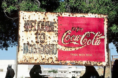
A rusty and bullet-ridden Coca Cola sign gives a telling welcome for visitors to the volatile city of Mogadishu. / Photo from khairi_us
Pictures from an armed convoy trip in Mogadishu / Photo from ctsnow
Mogadishu, an advanced former port has been witnessing the 17-year tussle between rival military camps since the fall of the government in 1991. It turned into the most chaotic and anarchic city of the world, marked by civil unrest and insurgencies. Such disturbances caused its original inhabitants to flee, leaving Mogadishu to be controlled by military factions. Only recently, a new federal government has taken up the reins of control and is trying to re-establish law and order.
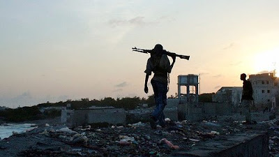
Photo from Kevin Sites in the Hot Zone

Another Seven Wonders Of The World

Another Seven Wonders Of The World

01 Banaue Rice Terraces (Philippines)


The Banaue Rice Terraces are 2000-year old terraces that were carved into the mountains of Ifugao in the Philippines by ancestors of the indigenous people. The Rice Terraces are commonly referred to by Filipinos as the "Eighth Wonder of the World". It is commonly thought that the terraces were built with minimal equipment, largely by hand. The terraces are located approximately 1500 meters (5000 ft) above sea level and cover 10,360 square kilometers (about 4000 square miles) of mountainside. They are fed by an ancient irrigation system from the rainforests above the terraces. It is said that if the steps are put end to end it would encircle half the globe. Read more after the break...

The Banaue terraces are part of the Rice Terraces of the Philippine Cordilleras, ancient sprawling man-made structures from 2,000 to 6,000 years old. They are found in the provinces of Kalinga, Apayao, Benguet, Mountain Province and Ifugao, and are a UNESCO World Heritage Site.

Locals to this day still plant rice and vegetables on the terraces, although more and more younger Ifugaos do not find farming appealing, often opting for the more lucrative hospitality industry generated by the Rice Terraces. The result is the gradual erosion of the characteristic "steps", which need constant reconstruction and care. Via — Link

02 Ajanta Caves (India)

Photo — Link

AJANTA is world's greatest historical monument recognised by UNESCO located just 40kms from Jalgaon city of Maharashtra, India. There are 30 caves in Ajanta of which 9, 10, 19, 26 and 29 are chaitya-grihas and the rest are monasteries. These caves were discovered in AD 1819 and were built up in the earlier 2nd century BC-AD. Most of the paintings in Ajanta are right from 2nd century BC-AD and some of them about the fifth century AD and continued for the next two centuries. All paintings shows heavy religious influence and centre around Buddha, Bodhisattvas, incidents from the life of Buddha and the Jatakas. The paintings are executed on a ground of mud-plaster in the tempera technique.

Conjures before one's vision, a dream of beauty- of caves, hidden in the midst of a lonely glen with a streamlet flowing down below, caves that were scooped out into the heart of the rock so that the pious Buddhist monk, out on mission to spread the tenets of Buddhism could dwell and pray, caves that the followers of Lord Buddha, embellished with architectural details with a skilful command of the hammer over the chisel, with sculpture of highest craftsmanship and above all, with the paintings of infinite charm.

At Ajanta, the paintings on the walls, illustrate the events in the life of prince Gautama Buddha, the founder of Buddhism and in the more popular Jatakas stories pertaining to Buddha's previous incarnation. According to the older conceptions, the Buddha wrought many deeds of kindness and mercy in a long series of transmigration as a Bodhisattva, before achieving his final birth as the sage of sakyas.

Incidentally they contain the scenes of semi-mythological history, the royal court and popular life of the ancient times, as told in romances and plays. Some pictures recall the Greek and Roman compositions and proportions, few late resemble to Chinese manners to some extent. But majority belongs to a phase, which is purely Indian, as they are found nowhere else. These monuments were constructed during two different periods of time separated by a long interval of four centuries. The older ones were the product of last to centuries before Christ and belong to Hinayana period of Buddhism in later part of 2nd century AD when Buddhism was divided into two sections, after the conduct of the fourth general council under another great king, Kanishka. Vai — Link


03 Sigiriya (Sri Lanka)

Photo — Link

Sigiriya (Lion's rock) is an ancient rock fortress and palace ruin situated in the central Matale District of Sri Lanka, surrounded by the remains of an extensive network of gardens, reservoirs, and other structures. A popular tourist destination, Sigiriya is also renowned for its ancient paintings (frescos),[1] which are reminiscent of the Ajanta Caves of India. The Sigiriya was built during the reign of King Kassapa I (AD 477 – 495), and it is one of the seven World Heritage Sites of Sri Lanka.

Sigiriya may have been inhabited through prehistoric times. It was used as a rock-shelter mountain monastery from about the 5th century BC, with caves prepared and donated by devotees to the Buddhist Sangha. The garden and palace were built by King Kasyapa. Following King Kasyapa's death, it was again a monastery complex up to about the 14th century, after which it was abandoned. . The Sigiri inscriptions were deciphered by the archaeologist Senarath Paranavithana in his renowned two-volume work, published by Oxford, Sigiri Graffiti. He also wrote the popular book "Story of Sigiriya".

The Mahavamsa, the ancient historical record of Sri Lanka, describes King Kasyapa as the son of King Dhatusena. Kasyapa murdered his father by walling him alive and then usurping the throne which rightfully belonged to his brother Mogallana, Dhatusena's son by the true queen. Mogallana fled to India to escape being assassinated by Kasyapa but vowed revenge. In India he raised an army with the intention of returning and retaking the throne of Sri Lanka which he considered was rightfully his. Knowing the inevitable return of Mogallana, Kasyapa is said to have built his palace on the summit of Sigiriya as a fortress and pleasure palace. Mogallana finally arrived and declared war. During the battle Kasyapa's armies abandoned him and he committed suicide by falling on his sword. Chronicles and lore say that the battle-elephant on which Kasyapa was mounted changed course to take a strategic advantage, but the army misinterpreted the movement as the King having opted to retreat, prompting the army to abandon the king altogether. Moggallana returned the capital to Anuradapura, converting Sigiriya into a monastery complex.

Alternative stories have the primary builder of Sigiriya as King Dhatusena, with Kasyapa finishing the work in honour of his father. Still other stories have Kasyapa as a playboy king, with Sigiriya a pleasure palace. Even Kasyapa's eventual fate is mutable. In some versions he is assassinated by poison administered by a concubine. In others he cuts his own throat when isolated in his final battle.[5] Still further interpretations have the site as the work of a Buddhist community, with no military function at all. This site may have been important in the competition between the Mahayana and Theravada Buddhist traditions in ancient Sri Lanka.
Via — Link


04 Leptis Magna (Libya)

Photo — Link

Leptis Magna, also known as Lectis Magna (or Lepcis Magna as it is sometimes spelled), also called Lpqy or Neapolis, was a prominent city of the Roman Empire. Its ruins are located in Al Khums, Libya, 130 km east of Tripoli, on the coast where the Wadi Lebda meets the sea. The site is one of the most spectacular and unspoiled Roman ruins in the Mediterranean. Via — Link


05 Meteora (Greece)

Photo — Link

The Metéora (Greek  "suspended rocks", "suspended in the air" or "in the heavens above") is one of the largest and most important complexes of Eastern Orthodox monasteries in Greece, second only to Mount Athos. The six monasteries are built on natural sandstone rock pillars, at the northwestern edge of the Plain of Thessaly near the Pineios river and Pindus Mountains, in central Greece. The nearest town is Kalambaka. The Metéora is included on the UNESCO World Heritage List under criteria. Via — Link


06 Bagan (Myanmar)

Photo — Link

Bagan, formerly Pagan, is an ancient city in the Mandalay Division of Burma. Formally titled Arimaddanapura or Arimaddana (the City of the Enemy Crusher) and also known as Tambadipa (the Land of Copper) or Tassadessa (the Parched Land), it was the ancient capital of several ancient kingdoms in Burma. It is located in the dry central plains of the country, on the eastern bank of the Ayeyarwady River, 90 miles (145 km) southwest of Mandalay.

Bagan was submitted to become a UNESCO heritage site but many speculate of politics as partly the reason for the exclusion. UNESCO does not designate Bagan as a World Heritage Site. The main reason given is that the military junta (SPDC) has haphazardly restored ancient stupas, temples and buildings, ignoring original architectural styles and using modern materials which bear little or no resemblance to the original designs. The junta has also established a golf course, a paved highway, and built a 200-foot (61-m) watchtower in the southeastern suburb of Minnanthu. Via — Link


07 Valley of Flowers National Park

Photo — Link

Valley of Flowers National Park is an Indian national park, Nestled high in West Himalaya, is renowned for its meadows of endemic alpine flowers and outstanding natural beauty. This richly diverse area is also home to rare and endangered animals, including the Asiatic black bear, snow leopard, brown bear and blue sheep. The gentle landscape of the Valley of Flowers National Park complements the rugged mountain wilderness of Nanda Devi National Park. Together they encompass a unique transition zone between the mountain ranges of the Zanskar and Great Himalaya. The park stretches over an expanse of 87.50 km².

The Valley of Flowers is an outstandingly beautiful high-altitude Himalayan valley that has been acknowledged as such by renowned mountaineers and botanists in literature for over a century and in Hindu mythology for much longer. Its ‘gentle’ landscape, breathtakingly beautiful meadows of alpine flowers and ease of access complement the rugged, mountain wilderness for which the inner basin of Nanda Devi National Park is renowned.

Valley of flower is splashed with colour as it bloomed with hundreds different beautiful flowers, taking on various shades of colours as time progressed. Valley was declared a national park in 1982, and now it is a World Heritage Site. The locals, of course, always knew of the existence of the valley, and believed that it was inhabited by fairies.

While trekking towards valley of flowers, tourists can experience the beauty of shining peaks fully covered with snow. Tourists can also see the beautiful view of surrounding greenery and various running streams with crystal clear water.

The valley is home to many celebrated flowers like the Brahmakamal, the Blue Poppy and the Cobra Lily. It is a much sought after haunt for flower-lovers, botanists and of course trekkers, for whom a sufficient excuse to embark on a mission to reach a place, is that it exists.

The Valley of Flowers is internationally important on account of its diverse alpine flora, representative of the West Himalaya biogeographic zone. The rich diversity of species reflects the valley’s location within a transition zone between the Zaskar and Great Himalayas ranges to the north and south, respectively, and between the Eastern Himalaya and Western Himalaya flora. A number of plant species are internationally threatened, several have not been recorded from elsewhere in Uttarakhand and two have not been recorded in Nanda Devi National Park. The diversity of threatened species of medicinal plants is higher than has been recorded in other Indian Himalayan protected areas. The entire Nanda Devi Biosphere Reserve lies within the Western Himalayas Endemic Bird Area (EBA). Seven restricted-range bird species are endemic to this part of the EBA.

The Valley of Flowers was declared a national park in 1982. This part of Uttarakhand, in the upper reaches of Garhwal, is inaccessible through much of the year. The area lies on the Zanskar range of the Himalayas with the highest point in the national park being Gauri Parbat at 6,719 m above sea level. Via — Link


08 Tower of Hercules (Spain)


The Tower of Hercules (Galician and Spanish: Torre de Hércules) is an ancient Roman lighthouse on a peninsula about 2.4 kilometers (1.5 miles) from the centre of A Coruña, Galicia, in north-western Spain. The name Corunna is said to be derived from the ancient columna, meaning column. The structure is 55 metres (180 ft) tall and overlooks the North Atlantic coast of Spain. The structure, almost 1900 years old and rehabilitated in 1791, is the oldest Roman lighthouse still used as a lighthouse.

The Tower of Hercules is a National Monument of Spain, and since June, 27 2009 the Tower of Hercules is also considered an UNESCO World Heritage Site. It is the second tallest lighthouse in Spain, after the Faro de Chipiona.

Construction and History

The tower remains a sentinel from days long past. It is known to have existed by the 2nd century, built or perhaps rebuilt under Trajan, perhaps on foundations and just possibly following a design that was Phoenician in origin. It is thought to be modeled after the Pharos Lighthouse of Alexandria. At its base is preserved the cornerstone with the inscription MARTI AUG.SACR C.SEVIVS LUPUS ARCHTECTUS AEMINIENSIS LVSITANVS.EX.VO, permitting the original lighthouse tower to be ascribed to the architect Gaius Sevius Lupus, from Aeminium (present-day Coimbra, Portugal) in the former province of Lusitania, as an ex voto dedicated to Mars. The tower has been in constant use since the 2nd century and considered to be the oldest existing lighthouse in the world. Originally it was constructed with an ascending ramp encircling its sides, for oxen to bring cartloads of wood to keep the light fueled at night.[citation needed]

The earliest surviving mention of the lighthouse at Brigantium is by Paulus Orosius in Historiae adversum Paganos written ca 415 – 417:
Secundus angulus circium intendit, ubi Brigantia Gallaeciae civitas sita altissimum farum et inter pauca memorandi operis ad speculam Britanniae erigit” ("At the second angle of the circuit [circumnavigating Hispania], where the Gallaecian city of Brigantia is sited, a very tall lighthouse is erected among a few commemorative works, for looking towards Britannia.") Vai — Link


09 Library of Celsus (Turkey)


The library of Celsus, in Ephesus, Asia Minor (Anatolia, now Turkey), was built in honor of Tiberius Julius Celsus Polemaeanus (completed in 135 AD) by Celsus’ son, Gaius Julius Aquila (consul, 110 AD). Celsus had been consul in 92 AD, governor of Asia in 115 AD, and a wealthy and popular local citizen.

The library was built to store 12,000 scrolls and to serve as a monumental tomb for Celsus. It was unusual to be buried within a library or even within city limits, so this was a special honor for Celsus. Via — Link


10 Torun' (Poland)

Source: santabanta.com


Torun' [?t?ru?] ( listen) (German: Thorn (Ltspkr.png listen), Kashubian: Torn', Latin: Thorunium, see also: other names) is a city in northern Poland, on the Vistula River, with population over 205,934 as of June 2009, making it the second-largest city of Kujawy-Pomerania Province, after Bydgoszcz. The medieval old town of Torun' is the birthplace of Nicolaus Copernicus. In 1997 it was added to UNESCO's World Heritage List as a World Heritage Site.

Previously it was the capital of the Torun' Voivodeship (1975–98) and the Pomeranian Voivodeship (1921–45). Since 1999, Torun' has been a seat of the self-government of the Kujawy-Pomerania Province and, as such, is one of its two capitals (together with Bydgoszcz). The cities and neighboring counties form the Bydgoszcz-Torun' bipolar metropolitan area. In September 2004, Bydgoszcz Medical School joined Torun''s Nicolaus Copernicus University as its Collegium Medicum.

Moon Shaped Skyscraper

 Moon Shaped Skyscraper

K0rean Heerim Architects has tried to reinvent the skyscraper with their two projects in central Asian republic of Azerbaijan. The two skyscrapers will be built in Baku, capital of Azerbaijan with a view on the Caspian sea . One building is called Full Moon Bay the other is Crescent and Caspian Plus. The two are going to be built on both side of the bay, acting as gateway markers. So far the pictures look fantastic and I really like the gateway markers idea.


Skyscraper Urban Forest

Skyscraper Urban Forest

Urban Forest, Chongqing, China
All images courtesy of MAD architects

MAD architects has sent us images of a new project, urban forest, located in chongqing, china. drawing on the mountainous landscape of the country, the commercial high-rise building, is made up of curved, abstracted shaped floors which have been layered slightly off-center from one another. Connected by a core cylindrical structure, each level's interior is protected by full length glass windows with a see-through, wrap around balcony. this provides transparency throughout the building, and makes the floors almost seem as if they are floating on top of one another. the overall design brings together nature and the urban metropolis, with the incorporation of green space and large expansive views of the city.  More images after a jump...


New tower in the Emirates — Nakheel Tower

New tower in the Emirates — Nakheel Tower

The latest design attempting to breach the dizzying heights of the Burj Dubai has been revealed as the multibillion dollar Nakheel Tower. Designed by the developments wing of major investment company Nakheel, the tower will be more than a kilometre high, covering a space of around 270 hectares, and will become home to around 55,000 people, a workplace for 45,000, and is hoped will attract millions of visitors each year. More images and video after a jump...
Nakheel Tower will comprise of four individual towers within a single structure, a distinctive crescent-shaped podium encircling the base and complementing the structure’s remarkable height. The multibillion-dollar development, commissioned by Sultan Ahmed bin Sulayem, chairman of Dubai World, will also include 250,000 sq m of hotels and hospitality space, 100,000 sq m of retail space and huge expanses of green spaces, including canal walks, parks and landscaping. The Tower itself, cited geographically central to Dubai at the intersection of Sheikh Zayed Road and the Arabian canal, will aim to complement surrounding developments, such as Jumeirah Park and Discovery Gardens.

In terms of design the architects have sought inspiration not just from Islamic design but also from the Islamic principles of inclusion, innovation, diversity, excellence, growth and progress: “These are the principles that have motivated and guided Islamic culture throughout history. Now they are shaping the cities of the future,” explained Sultan Bin Sulayem. To this end, the architects have sought inspiration and incorporated elements from the great Islamic cities of the past such as the gardens of Alhambra in Spain, the harbour of Alexandria in Egypt, and the bridges of Isfahan in Iran.

Sustainability and safety will be key to the development of the tower, with the latest standards and technology incorporated in its development, Sultan Bin Sulayem believes it will “send another message to the world that Dubai has a vision like no other place on earth.” Via Link


Forget the 3,280 feet-high 200-floor Nakheel Tower because it’s no longer going to be the highest skyscraper in the world. The new upcoming beast is this amazing 1.55-mile-high skyscraper planned for the Jumeirah City project in Dubai. The building is so tall that its main elevator is in fact a vertical 125mph bullet train. This city-in-a-skyscraper will consume 37,000 megawatts per hour per year, with a 15MWH peak usage, but as the plans show, it has been designed to generate most of it using wind, thermal, and solar power.